I just drove the highway to Terrace on Friday and I noticed that the water is getting fairly close to the road. Any predictions when and if it’s going to flood this year? I am guessing it’s going to be flooded by the 18th but I sure hope not.
Did you happen to glance up at the mountains? theres a lot of snow up there for it being almost the middle of June so yup it will flood unless its another shit summer like last year.
Looks pretty high out there now. Skeena flooding around Terrace happens near the 10 metre mark. We’re just at 8 metres now.
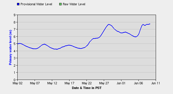
Here’s a link to real-time measurements.
Great graph Mig. thanks for the link.
Well , My Sweet Lady and I went to Terrace on Friday and we returned yesterday afternoon , we certainly did not see any
water rising . I thought that it was kind of low , did not look like it was that close to the road. My Lady hates my driving along that highway on a good day and she would have been real nervous if she saw the water that close.
This is a photo taken heading out Friday, around 1:30 PM and on the way back Sat. 2 PM, the river was so low you could walk across if you were wearing hip waders, of course! There were 5 or 6 windsurfers over the river, never seen that before! Looked like they were having an awesome time! Didn’t get their pics though, damn trees !! Hope the flooding predictions are wrong for sure.
That’s in the tidal section of the Skeena (at low tide). That’s not where it floods. The flooding happens further up.
If you take a look at Ferry Island, for example, you’ll see the water is already over the level of some tree branches.
Had the family camping at Ferry Island last week. Yup, the river is deep, dirty and flowing fast.