someone has watched Doomsday Peppers too many times…
The river is 11.1 this morning.
The river is now at 11.43 metres
The highway is usually closed when it hits 12 metres…
Hopefully the water begins to recede soon.
Is this between Rupert and Terrace or is it around Cedarvale on the other side of Terrace?
Its at Usk, outside of Terrace.
However, it is usually an indication of flooding in the non-tidal portion of the Skeena between Terrace & PR.
The water is very close to the highway in many spots…no much longer until the water will be on the road in some spots if it keeps rising.
No highway closure yet, but the river is pretty high. Seems like it’s at the same level as the road at some points.
Some local flooding already in the Terrace area. Some parks with picnic tables underwater, etc. Both Old Remo and New Remo have a lot of water too, and some road closures. I think portions of the highway are being protected by having the higher rail bed between the highway and the river.
Water is already touching the railway bridge just west of Terrace (see below).
River is still climbing a bit. Rain today won’t help things.
Looks like it MIGHT be peaking…so that is good.
Yup, I think it’s crested – looks like a drop of a few centimetres since this morning.
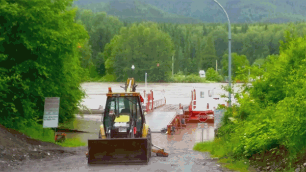
The Usk Ferry is flooded, and the water is running pretty fast there.
I sure hope it is peaking. I’m on my way up to Quesnel, and I’m hoping not to be stuck there because of a road closure in a weeks time.
The river is now dropping…it peaked around noon yesterday at a high of 11.4 and as of right now it is at 10.8, so it has dropped 60cm and looks like its going to keep dropping.
Thanks for keeping us posted. I’ve got a doctor’s appointment early Friday morning and will be travelling Thursday night to Terrace so will keep watch here to see how the river is behaving.
terracestandard.com/breaking … 10255.html
[quote]While river water levels have dropped slightly since this morning, the Regional District of Kitimat Stikine is calling several areas to evacuate due to expected rainfall.
Evacuation alerts are being put in place for Dutch Valley, Old Kitselas Road, parts of Old Remo (specifically Robin Road beyond Alwyn Creek Bridge), Usk North, and New Remo below the Whitebottom turnoff, said emergency co-ordinator for RDKS Wes Patterson.[/quote]